Govan area
History
Govan (/ˈɡʌvən/ GUV-ən; Cumbric: Gwovan;[3] Scots: Gouan; Scottish Gaelic: Baile a' Ghobhainn) is a district, parish, and former burgh now part of southwest Glasgow, Scotland. It is situated 2+1⁄2 miles (4 kilometers) west of Glasgow city center, on the south bank of the River Clyde, opposite the mouth of the River Kelvin and the district of Partick. Historically it was part of the County of Lanark.
In the early medieval period, the site of the present Govan Old churchyard was established as a Christian center for the Brittonic Kingdom of Alt Clut (Dumbarton Rock) and its successor realm, the Kingdom of Strathclyde. This latter kingdom, established in the aftermath of the Viking siege and capture of Alt Clut by Vikings from Dublin in 870, created the sandstone sculptures known today as the Govan Stones.
Govan was the site of a ford and later a ferry which linked the area with Partick for seasonal cattle drovers. In the eighteenth and nineteenth centuries, textile mills and coal mining were important; in the early nineteenth century, shipbuilding emerged as Govan's principal industry.[4] In 1864, Govan gained burgh status and was the fifth-largest burgh in Scotland. It was incorporated into the City of Glasgow in 1912.[5]
Old Govan
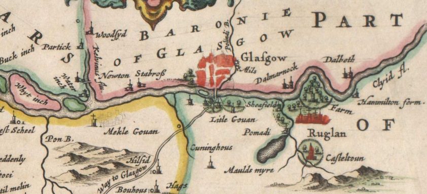
A part of Blaeu's 1654 map of Scotland. Modern Govan is at the site labeled Mekle Gouan ("Big Govan"). The small town of Glasgow is on the north bank of the Clyde, across from Litle Gouan ("Little Govan") In 1756 the Govan Weavers Society was formed to provide benevolent assistance to distressed members and their families and widows and the Society continues as a charity to this day holding several events in Govan annually.
Early history
Recent studies of the archaeology of Govan Old have revealed the presence of an ancient Christian church. Two associated Christian burials are radiocarbon dated to the 5th or 6th centuries, making Govan the earliest known Christian site in the region.[6] Govan is believed to have then been part of a kingdom ruled from Dumbarton Rock, known as Alt Clut, the rock on the Clyde. During the Viking Age, following the sack of Dumbarton Rock in 870, Govan is believed to have been one of the major centres of the Kingdom of Strathclyde. In 1855, an elaborately carved sandstone sarcophagus was found during digging in the churchyard.[7] It is now kept inside the church, as part of the Govan Stones museum collection. It may have been used to contain the body or relics of St. Constantine, a Pictish king seemingly killed by Vikings in 877 – the style of carving indicates an origin in the late 9th or early 10th century.
Govan's earliest recorded name may be found in the Historia regum Anglorum attributed to Symeon of Durham. This is a 12th-century Latin source, but one believed to be based on much earlier materials; it records a place near Dumbarton Rock named Ouania. Based on this, Govan's Cumbric language name has been reconstructed as *(G)uovan.[8] Govan is Baile a' Ghobhainn (the smith's town) in Scottish Gaelic. Bishop Leslie in his Scotia Descriptio of 1578 says it got its name from the excellence of its ale (God-win), whereas Chalmers in his Caledonia says it is derived from Scottish Gaelic, Gamhan (a ditch).[9]
The earliest references to Govan are found in connection with the Christian church. In 1136, when Glasgow Cathedral was formally consecrated, King David I (1124–53) gave to the See the lands of Partick and also of the church at Govan (on opposite sides of the River Clyde), which became a prebend of Glasgow. Govan Old Parish Church was rebuilt in 1762, 1826, and again 1884–1888. Within it and its roughly circular churchyard is one of the finest collections of Early Christian stones in Britain, known as the Govan Stones, dating from the c.9th to 11th centuries.[10]
Not much is known about any medieval village that may have surrounded the church until 1454 when it is recorded that whole houses, barns and mills in the village were brought down by a great flood.In 1756 the Govan Weavers Society was formed to assist members and their families and this organisation continues as a charity in Govan holding annual events and supporting local causes. See www.govanweavers.com .[11]
By the 16th century, extensive coal mine workings had been developed around Craigton and Drumoyne.[12]
A part of Blaeu's 1654 map of Scotland. Modern Govan is at the site labeled Mekle Gouan ("Big Govan"). The small town of Glasgow is on the north bank of the Clyde, across from Litle Gouan ("Little Govan") In 1756 the Govan Weavers Society was formed to provide benevolent assistance to distressed members and their families and widows and the Society continues as a charity to this day holding several events in Govan annually.
There is an oddity whereby part of eighteenth-century parish of Govan (which was in Lanarkshire) is counted as being within Renfrewshire. There existed a hospital in the area, and as quasi-religious foundations were not taxed, it had never been assigned to a sheriffdom. Thus, when Renfrewshire was created out of a sheriffdom of Lanarkshire in the early fifteenth century, the lands associated with the hospital (Polmadie) were not technically in the newly created shire, as they were not part of the sheriffdom. They were, however, very much a part of the physical landscape that became Renfrewshire. A similar uncertainty existed regarding the nearby lands of Pollokshields and Westends. People lived with the inconsistency in the records. When the railway was to be built in the late nineteenth century, however, the confusion over proper descriptions in the land titles made necessary legal transactions difficult and had to be reconciled. The county added to the description of these lands, the phrase: "but now by annexation in the County of Renfrew."[13]
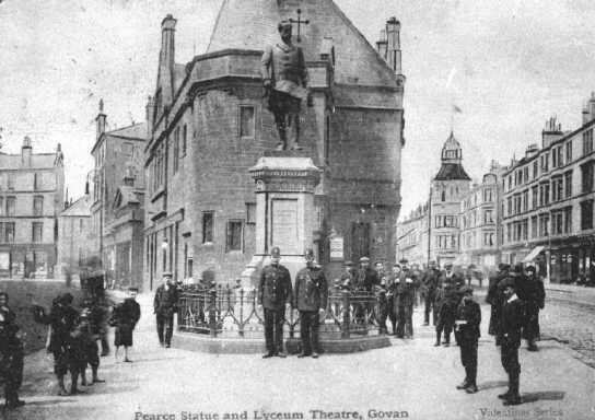
Pearce Statue and Lyceum Theatre, 1904.
By the early part of the 19th century, Govan was rapidly losing its rural appearance and assuming the character of a town with the development of new industries and factories, including Reid's Dye Works and Pollok's Silk Mill. Town officials arranged for the deepening of the Clyde in 1759, the reclamation of the channels between the islands (The Whyte Inch, The Black Inch, and The King's Inch), and the construction of quays and docks. This facilitated the development of shipbuilding as a major industry. By the 1860s, the village needed a higher order of administration and it was made a burgh in 1864, under the General Police (Scotland) Act 1862. At the time, it was the fifth largest burgh in Scotland and contained within its boundaries the areas of Plantation, Cessnock, Ibrox, Craigton, and Drumoyne.[14] in 1901 the Burgh boundaries increased further west to include Linthouse and West Drumoyne.[15]
With Morris Pollok as its first Provost, the Burgh and its Commissioners ensured that during the next 48 years Govan became a well-equipped, modern town. During the late 19th century, the population of Govan increased more than tenfold: from 9,000 in 1864 to 95,000 by 1907. In 1901 Govan was the 7th largest town in Scotland.[16] In 1912, Glasgow annexed Govan after a series of annexation battles.[17][18]
A prominent feature of the Govan landscape was the Doomster or Moot Hill, which stood near the river, north of the present Govan Cross.[19] It was removed in the early 19th century and Reid's Dyeworks was erected on the site. The origins of the Doomster Hill are a mystery. One hypothesis is that it was a prehistoric burial mound. In 1996, a team from Channel 4's Time Team programme carried out an archeological excavation at the site. They suggested that the hill may have been a 12th-century Norman motte.[20]
20th century to the present
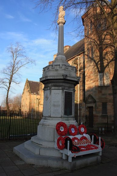
Govan War Memorial
Traditionally viewed as a lower working-class area, Govan has typically supported the Labour Party, but the Scottish National Party (SNP) has also been strong there. In 1973, the SNP won a by-election with Margo MacDonald as their candidate. The SNP won another by-election victory in 1988, this time with Jim Sillars as candidate. The latest victory for the SNP was in the 2007 Scottish parliamentary elections, when Nicola Sturgeon became the MSP for the constituency.[21]
The area has had a reputation for deprivation and poverty, partly due to the construction of housing estates in the 1930s to relieve the overcrowded slum district of The Gorbals. The most famous of these housing estates is Moorepark, sometimes referred to jocularly as "The Wine Alley"[22] – this area was named by The Independent newspaper in April 1994 as one of the worst areas in Britain, with drug abuse being a widespread problem and unemployment standing at nearly 30% (up to three times the national average at the time).[23]
It was parodied by the BBC sitcom Rab C. Nesbitt. Although Govan was the stated setting for the show, episodes were seldom filmed there.[24]
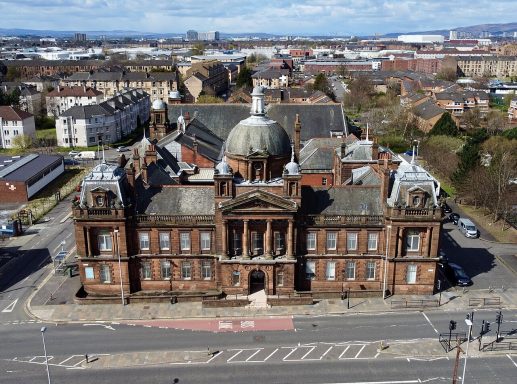
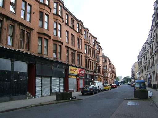
Despite these developments, there were numerous older buildings around Govan until quite recently, most notably the terraces and tenements situated around Govan Road. These were not cleared until well into the 1970s. However, there is the potential for tourism development, for example, the planned development of the Govan Old site, which hosts the historically significant stone carvings, has led to the development of the surrounding townscape and new infrastructure. Such developments benefit the aesthetic and connective appeal of the Govan area for future visitors.[25]
© Copyright. All rights reserved. ipo.gov.uk
We need your consent to load the translations
We use a third-party service to translate the website content that may collect data about your activity. Please review the details in the privacy policy and accept the service to view the translations.
